
 Blackberry RIM (26-06-2013)
  Windows Phone (16-10-2015)
Track reviewing
-
When the whole system (application and website) has been set up, you can start using it and GPS data will be collected. To review the position of any of your devices you can go to menu option Devices -> Tracking and you will load the locations stored on a practical dynamic map.
If you are a premium user you will see all the GPS points gathered by premium devices, if your device runs as a basic user, you will see just the last positions transfered to the website.
Anyway, for every user the tracking page is built on:
- Search tools: At the beginning of the page you may filter the data shown in the map by: device, date and time. It also lets you filter the results by the source of positioning data: GPS satellites or GSM telephone network (if available).
-
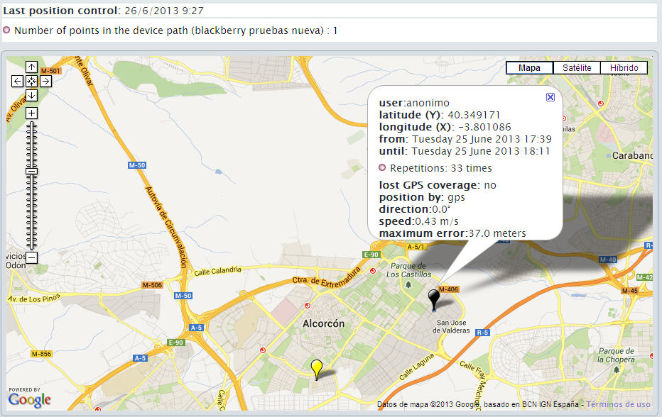
Dynamic map:
Shows the locations transfered by the devices drawn on the map. The platform adds a virtual line linking points to help users track movement, but this line does not represent real coordinates the device has been at.
If you click on any of the points on the map, full data of the point will display:
- Device's user name
- Latitude and longitude of the position
- Date and time the device was at that position
- Date and time the device was at that position for the last time
- Number of times the device sent that position (means how long the device didn't move)
- Information about the point reliabily (e.g. if it is an estimated location because there was no positioning source at that time).
- Souce: GPS (more reliable and accurate) or Telephone Network (if available, larger error margin)
- Direction (degrees) and speed (meters per second) when position was stored
- Maximum error (in meters) according to positioning source. Due to lack of visibility of satellites, bad weather conditions, etc. stored positions might not be fully accurate, although an error margin of 50 meters doesn't mean at all that the position is 50 meters wrong, only that "it could be up to 50 meters wrong" or "it might 100% accurate".
Note that telephony network positions might have very large error margins because they have not been designed to position devices, so they will be ignored if there is GPS data available. - Street information, if available, to help you identify the position shown.
 It is also possible to print the locations map in a fast and convenient way, using a button at the bottom of the page. In addition to printing the locations shown on the map, it is possible as well to print any location balloon information visible on the map.
-
Once you have set up all your devices in your account profile, you may check any device's last known location visiting the menu Devices -> Last known location where you will see a map showing latest positions sent by all your devices.
Location map page is made up of:
- Search tools: Search tools let users filter the device's locations to show on the map.
-
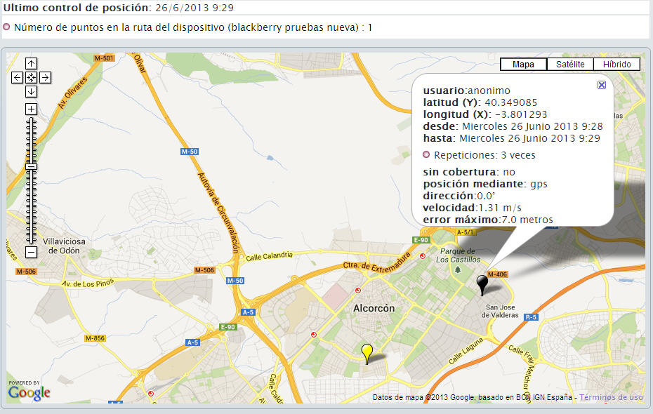
Map:
Presenta los ultimos puntos almacenados de los dispositivos seleccionados. Sobre este mapa se van a "dibujar" los puntos obtenidos de la búsqueda.
The map shows the newest locations recorded for any selected devices. Those locations may not be the real location the device is right at the moment, as they are the last location sent from the device. Clicking on any of those points will show a tooltip with detailed information about it:
- Device user
- Recorded location latitude and longitude.
- Recording date and time
- Last date and time the device was located there.
- Amount of consecutive track attempts at that same location.
- Whether location data is reliable or estimated (there is no GPS or mobile coverage)
- Positioning network used to obtain location: GPS (more reliable and exact) or Mobile Network (larger error margin).
- Direction (measured in degrees) and speed (measured in meters per second) of the device at the moment the tracking data was recorded.
- Maximum error margin expected for recorded location. Due to lack of coverage, or bad weather conditions track data may not be too reliable. This value is a maximum, which does not mean recorded location will always be in error (in fact, most of the time tracking data is fairly exact, although error margin value might be high).
Please notice that locations obtained from Mobile Network provider may have very large error margins as they are based on mobile network repeaters available in that area, and they may bien thousands of meters away from each other. This location provider will never be used if GPS provider is available. - Street information, if available, to help you identify recorded locations.
Last location map
-
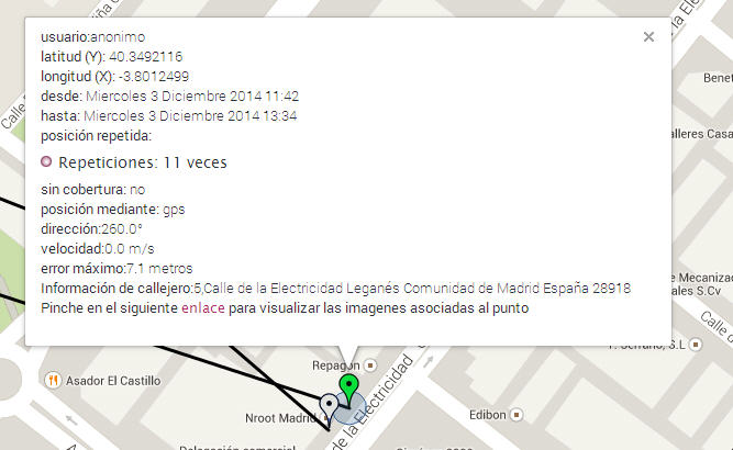
This new service, only for premium devices and not available yet for all mobile platforms, lets our mobile application take a picture that our system will tag with an automatic timestamp and location info and will send to main servers. That way, the picture will be saved as an evidence of the exact location where it was taken (provider error margin will not be a problem any more) and will be a perfect evidence to verify employees locations at all times.
Image capture: Android
Within the application there is a button to take the pictures to be send to ndonde's servers linked to current position and moment.

Once the button is pressed, the device's "camera" application opens and lets the user take a picture. When the picture is saved by the user, our application will send it to our server inmediatelly (or will store it locally if there is no available connection to Tnternet, until network coverage is available again).
This new feature will not be available on any of these situations:
- Device's memory is full and pictures cannot be saved.
- Device has not premium mode enabled. In this case, pictures sent to our server from the device will be discarded.
- Device has no camera or its camera is not working.
Corrupted or invalid pictures received by our server will be discarded. In such situation, location tracking info will be recorded but picture won't.
Once a picture has been uploaded and recorded successfully it will be available from tracking map clicking on that point to raise its details.
-
It is possible to share last position of your devices as a public map. To set this up, you need to follow these steps on any device whose position you want to share:
- Set the device as public. To configure a device as public you just need to navigate to the device list from menu item Devices -> Manage Devices and then click on edit the desired device.
- On the device set up page, you will then have to click on "Regenerate" button, at public key fieldset. Clicking on that button will create a unique public key for current device. Clicking on "Remove" button will set the device back to private mode, being then mandatory to have the right credentials to see its position.
- After refreshing the device list at Devices -> Manage Devices you will be able to see the public URL which will allow anyone to see a shared map with last known positions of the device.
It is also possible to access the public map directly, for integration in third-party websites with configurable width, height, and zoom level.
Sharing last position on a public map
return